July 31, 2024 Road Updates

Joe kasprzak • July 30, 2024

July 31, 2024 9:00 am- St. Johnsbury Flood Updates

July 31, 2024, Update: The Town of St. Johnsbury received significant rainfall on July 30, 2024, causing substantial flooding and road closures. Town officials opened the local Emergency Operations Center (EOC) at 3 am. The state of Vermont deployed the Vermont Urban Search and Rescue Task Force and other swift-water teams from around the state to assist with emergency operations. St. Johnsbury rainfall totals report between 4" -8.4" of rainfall. Significant damages and road closures have been reported.  At 8am today Town officials reopened the St. Johnsbury Welcome Center at 51 Depot Square to serve as the temporary evacuation shelter.


Damage has been reported at the Town's water treatment plant and staff has temporarily restored the town's ability to produce water with hopes of having the plant fully operational by noon today.


  July 31, 2024 Road Update: 9am  

·        Stealth Ridge- closed

·        Gilman- passable with caution

·        Concord Ave.– closed between Almshouse & Gilman

·        Farmer Drive near Morgan Circle bridge washout

·        Morgan Circle- washout

·        East Village Road - closed

·        Severance Hill Road- closed at Red Village Road

·        Memorial Drive – Between St. J. GMC/St. J. Ram/Chrysler/Jeep

·        Memorial Drive- closed at Consolidated Communications

·        Memorial Drive- closed at Golden’s Studio & Barber Shop

·        Route 5 – open for one lane of traffic at Vermont State Police barracks

·        High Street- passable, use caution

·        Mt. Pisgah Road- closed

·        Spaulding Road- closed

·        Cliff Street- issues reported and checking

·        Tilton Road- washouts reported

·        Mt. Vernon- washouts reported, but passable

·        Oak Street- back end washouts reported

·        Assisqua Avenue– closed

·        Breezy Hill Road – closed

·        Rodd’s Road- closed

·        Old Concord Road- closed

·        Chesterfield Hollow- closed

·        Willey Farm Road- closed

·        Bridge on Route 2 east of Severance Hill Road – closed

·        Barker Avenue- washouts reported

·        Crow Hill – washouts reported, passable

·        River Road- closed at 1688 River Road


By Joe kasprzak September 14, 2026
Caledonia Food Cooperative VCDP CDBG Public Hearing 09-14-2026
September 10, 2026
Saturday, September 26th, 2026
September 10, 2026
Cemetery Rules & Seasonal Decoration Removal
September 9, 2026
The St. Johnsbury Energy Committee meeting for September has been postponed to September 21st.
September 8, 2026
September 4, 2026
Saturday, September 12th, 2026
August 25, 2026
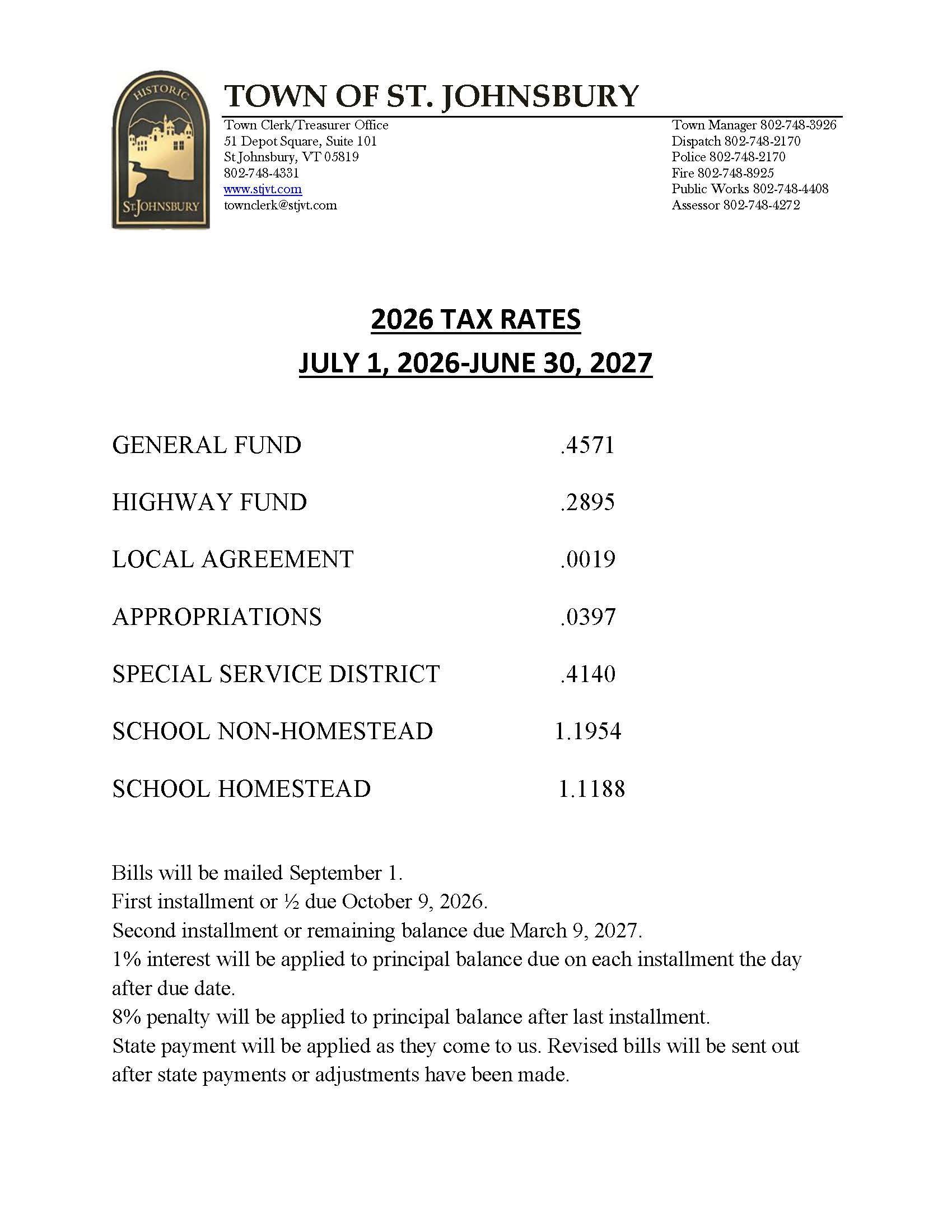
Any questions regarding your tax bill please call the Town Clerk's Office at 802-748-4331.
August 25, 2026
August 25th 8 am until 2 pm
August 12, 2026
August 2026
August 7, 2026
Early Notice and Public Review of a Proposed Activity in a Floodplain Town of St. Johnsbury, Vermont To: All interested Agencies, Groups, and Individuals The Northern Border Regional Commission (NBRC) intends to fund the following Proposed Action under the Catalyst Program. NBRC will prepare an 8-Step Decision-Making Process review in compliance with Executive Order (EO) 11988 (Floodplain Management), to ensure federally funded projects consider floodplain impacts and avoid unnecessary risks, as well as to avoid direct or indirect support of new construction in floodplains where there is a practicable alternative. Proposed Action: The purpose of the Proposed Action is to address the lack of a dedicated bicycle/pedestrian connection between the Lamoille Valley Rail Trail (LVRT) and St. Johnsbury’s Designated Downtown. The Proposed Action would enhance safety and accessibility for trail users by connecting the LVRT to the Three Rivers Path and St. Johnsbury’s downtown riverfront area to enhance recreational opportunities and promote the economic revitalization of St. Johnsbury. Specifically, the Proposed Action includes the construction of an approximately 2,600-foot-long multi-use path extension along the western side of Bay Street. Lighting would be installed along this length as well as the portion of the previously constructed path to the existing trailhead. The proposed path extension would begin at the Main Street LVRT Trailhead at 493 Main Street in St. Johnsbury, Vermont, at the approximate geographic coordinates of 44.4097081, -72.0181651. After crossing Main Street to Bay Street, the proposed path would continue along Bay Street to extend to the southern terminus of the existing Three Rivers Path just south of the Green Mountain Power (GMP) Bay Street Substation at 311 Bay Street. It has been determined by a review of Flood Insurance Rate Map (FIRM) Panel Number 5000310015B that portions of the Proposed Action would be located within a 100-year floodplain (Zone A7), warranting analysis under the 8-Step Decision-Making Process. Most of the land between the existing Three Rivers Path and the LVRT trailhead at Main Street lies within the 100-year floodplain of the Passumpsic River. The calculated fill volume for all new material being placed below the base flood elevation is approximately 978 cubic yards. The Proposed Action is subject to local review and approval per the Town of St. Johnsbury Flood Hazard Regulation, which includes review by the Rivers Program of the Vermont Department of Environmental Conservation. This notice provides people who may be affected by the Proposed Action and those who have an interest in the protection of the natural environment with an opportunity to express their concerns and provide information. Commenters are encouraged to offer alternative sites, alternative methods to serve the same project purpose, and methods to minimize and mitigate impacts.  Comments should be submitted by email to nepa@nbrc.gov . NBRC is accepting comments on this notice for 15 days from August 8, 2026 , through the end of the day of August 23, 2026 . Date of Publication: August 7, 2026